What is the probability of snowfall? Here’s Your Early Winter Weather Outlook for NYC Area
The last two winters have had above-average temperatures and a few bone-chilling cold outbreaks. Here’s what to expect in terms of snow and other Winter weather this season.
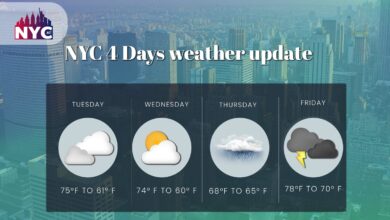
Trees are dropping leaves, temps are dropping, and the holiday season is heating up. Winter is quickly approaching, and it’s time to prepare for the tri-state area’s notoriously unpredictable winter weather. Snow, whether you love it or despise it, is constantly on everyone’s mind when it comes to the winter forecast. “How much snow can we expect?” We need to go back – to our last two winters — for the greatest response. These can be summarized as follows:
- Temperatures that are higher than typical for the season as a whole
- A couple icy blasts to make your teeth clatter
- One or two major snowstorms that cause school closures
Central Park
Central Park had 39 inches of snow during the winter of 2020-21. The average winter snowfall is 30 inches, so we had more snow than usual. However, the majority of that occurred from a single large storm on February 1, 2020, which poured 17 inches. The rest of our snow fell in smaller chunks that season. The same thing happened last winter. On January 29th, the season’s only “major” snowfall dumped 8.5 inches of snow. Other lesser snowfalls increased the season total to 18 inches.
This winter’s weather trend is looking fairly similar.
Here’s how the seasonal forecasts from the National Oceanic and Atmospheric Administration (NOAA) and AccuWeather stack up.
Seasonal Forecast
The NOAA’s Climate Prediction Center released its seasonal temperature outlook last month, and Staten Island is expected to be among the places with above-normal temperatures from December through February.
While the prognosis has moved significantly since the previous month’s estimate, Staten Island still has a 40% to 50% possibility of seeing greater temperatures than usual during the winter months in August. According to AccuWeather, Staten Island will have temperatures that are two to three degrees warmer than normal for December. AccuWeather predicts an upward departure closer to three degrees south of Staten Island, in accordance with NOAA’s forecasts for a warmer-than-usual winter.
Predictions
Temperatures that are slightly higher than average but still below freezing can contribute to the formation of enormous storms. Predictions for the forthcoming winter predict that precipitation levels in New York City will be about average, however, regions of Western New York may have above-average precipitation. Since predictions were issued just under two months ago, the forecast for the area has remained largely unchanged.
AccuWeather predicts below-average snow accumulations for Staten Island and parts of the New York City metro area. While the average snowfall at New York City’s Central Park climate station is 29.8 inches, AccuWeather anticipated six to nine days of accumulation, resulting in 18 to 23 inches of precipitation. Last winter, the station received just under 18 inches of snow.
However, the significant variability of La Nia winters — especially after three consecutive seasons influenced by the climate phenomenon that happens when the water near the equatorial Pacific Ocean is cooler than typical — presents forecasters with a difficult issue[1].
Analog Analysis & Other Factors
The use of analogs in a winter forecast has long been disputed and studied. How much weight should a forecaster place on what has happened in the past vs what is happening now? How can we use past experiences when the atmosphere is practically likely to react differently each time, especially given the variation in NYC weather between 1950s and 1960s weather events? Each winter is unique for us. The number of analog years that meet the set of variables and the overall evolution of the environment is quite limited this year. There have been very few years with a third year La Nia, which is projected to weaken with identical stratospheric and tropospheric evolutions over the world.
With this in mind, we chose to carefully weigh the analog years in our forecast, starting with the strongest year(s) and blending rapidly downward toward the weaker analogs. We are satisfied with the analog composites supplied and have integrated them into our projection as we normally do. Consider them to be a piece of a much broader forecast puzzle.
Pieces of information
When we combine the many pieces of information into one orderly prediction, we can begin to see the ebbs and flows of the upcoming winter as they should be, based on our best analogs and analysis of present and past conditions. We are confident in our month-to-month composites for winter and have expressed moderate to high confidence in each month.
Each month’s temperature and precipitation trends are broken down below. While precipitation maps aren’t presented (due to a lack of certainty), we do analyze precipitation patterns and potential inside each month’s breakdown. Please keep in mind that while this forecast focuses on New York City, nationwide issues are also highlighted.
SNOWFALL IN DECEMBER
Unlike November, when snow is uncommon, snow falls on average every 2-3 days in December, with 1 day having a snowfall of 1 inch (2.5 cm) or more. Snowfalls at 3 inches (7.6 cm) or more happen rarely every other year. Snow totals in December have ranged from a trace to nearly 30 inches (76 cm); however, the long-term average is closer to 5 inches (13 cm).
The likelihood of snow increases throughout December, with the end of the month nearly three times more likely to experience snow than the beginning. In any case, you’re more likely to encounter freezing rain than snow in December[2].
JANUARY SNOWFALL IN NYC
Snow falls on approximately four days each month in New York City, with two days often receiving at least one inch (2.5 cm) of snow and one day receiving three inches (7.6 cm) or more. January has experienced as little as 0 inches to as much as 36 inches (92 cm) in the past, but the long-term average is around 7 inches.
As high latitude blocking continues to influence the pattern across the Northern Hemisphere, the prediction for January depicts a volatile and cooler-than-normal trend across the Great Lakes, Upper Midwest, Ohio Valley, and Interior Northeast regions. Ridging is expected to develop and increase in sections of the Four Corners and Western US, assisting in pattern amplitude across the board.
FEBRUARY SNOWFALL IN NYC
The prognosis for February is quite unpredictable and will be heavily dependent on how ENSO conditions evolve over the Tropical Pacific during the winter months. Even by normal standards, this is an extremely low-confidence prognosis.
Cold risks are highly unpredictable at this time, particularly their location, breadth, and intensity, and as a result, only a few colder-than-normal places were included in the map.
MARCH SNOWFALL NYC
The snowfall risk decreases fast in March, but you can still anticipate 2 days with some snow and 1 day with snowfall of 1 inch (2.5 cm) or more.
Snowfalls of 3 inches (7.6 cm) or more occur rarely every other year or so.
Snowfall totals in March have ranged from 0 inches to nearly 31 inches (79 cm) in previous years; however, the typical snowfall in March is around 4 inches (10 cm).
HOW MUCH SNOW IN NYC THIS WINTER?
As previously stated, several factors influence how much snow and precipitation fall in New York City during any given winter. And estimates for any specific snow event aren’t reliable until around two weeks out. However, the best snowfall forecast for the Big Apple this winter is for near-normal totals.
The normal winter snowfall in New York City is roughly 25 inches, thus Ocean Weather Services predicts that the winter of 2022-23 will be between 22 and 27 inches. Precipitation in New York City is expected to be normal this winter, according to early estimates. Early indicators suggest that winter temperatures in the eastern United States, including New York City, will be warmer than usual. Warm water temperatures along the US East Coast may exacerbate coastal storms and cause locally heavy snow occurrences over the US Northeast as winter progresses.
FAQs
1 Will the winter of 2022 be harsh?
AccuWeather predicts that a vast chunk of the country will receive less snow than usual. AccuWeather’s official 2022-2023 U.S. winter forecast is not promising for snow enthusiasts.
2- In New York, what month is it most likely to snow?
January
Because of the cold, January is the most probable month to experience snow and ice, with an average of 6 days of snowfall.
NYC Forecast Review & Summary (December, January and February)
This winter in New York City is projected to have a near-normal temperature profile, with colder risks early in the season and warmer risks later in the season. Precipitation is expected to be above average over the winter months. Snowfall is forecast to be somewhat above average. It’s worth noting that current forecasts call for a colder start than typical – which isn’t saying much. The last few Decembers in New York City have been quite mild, with little snowfall. December and January could be very different this year.
References
[1] John Homenuk, 2022, NYC Winter Forecast 2022-2023: Colder start, active and warmer finish[https://www.nymetroweather.com/2022/11/11/nycwinterforecast2022]
[2] HeadTopics, 2022, How Much Snow Will We Get? Here’s Your Early Winter Weather Outlook for NY Area[https://headtopics.com/us/how-much-snow-will-we-get-here-s-your-early-winter-weather-outlook-for-ny-area-31572698]